
Thank you for supporting this site ❤️
Make a donation
Make a donation
Gear up for your next adventure:
As an Amazon Associate, this site earns from qualifying purchases at no extra cost to you.
Collicello topographic map
Click on the map to display elevation.
Thank you for supporting this site ❤️
Make a donation
Make a donation
Gear up for your next adventure:
As an Amazon Associate, this site earns from qualifying purchases at no extra cost to you.
About this map
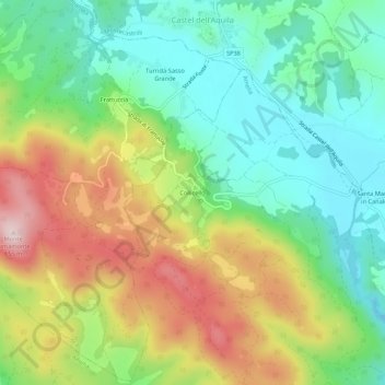
Name: Collicello topographic map, elevation, terrain.
Location: Collicello, Amelia, Terni, Umbria, 05022, Italia (42.59722 12.38388 42.63722 12.42388)
Average elevation: 1,440 ft
Minimum elevation: 1,004 ft
Maximum elevation: 2,126 ft
Thank you for supporting this site ❤️
Make a donation
Make a donation
Gear up for your next adventure:
As an Amazon Associate, this site earns from qualifying purchases at no extra cost to you.