Geolocate

Nalaikh topographic map

Click on the map to display elevation.

About this map

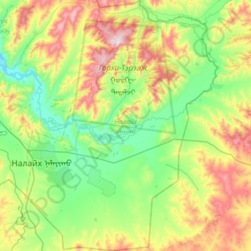
Name: Nalaikh topographic map, elevation, terrain.

Location: Nalaikh, Ulaanbaatar, 12770, Mongolia (47.64626 107.21763 48.00035 107.62131)

Average elevation: 5,249 ft

Minimum elevation: 4,390 ft

Maximum elevation: 7,208 ft

Other topographic maps

Click on a map to view its topography, its elevation and its terrain.

Bogd Khan Mountain

Mongolia > Ulaanbaatar

Average elevation: 6,302 ft

Gear up for your next adventure:

📌Outdoor GPS Map App - Apps and devices for digital topographic navigation
🧤Hiking Gloves - Protective gloves for rugged trails
🔥Plasma Lighters - Windproof lighters that work in any weather condition
📡Handheld GPS Device - Reliable handheld GPS for outdoor navigation
🎒Trekking Poles - Sturdy poles for balance and stability on rough terrain

As an Amazon Associate, this site earns from qualifying purchases at no extra cost to you.