Geolocate

Pfaffenried topographic map

Click on the map to display elevation.

About this map

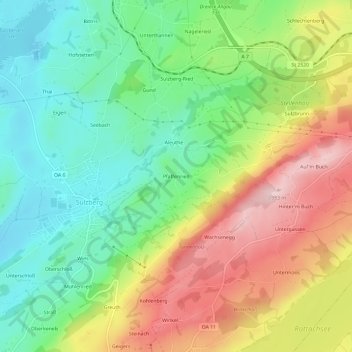
Name: Pfaffenried topographic map, elevation, terrain.

Location: Pfaffenried, Sulzberg, Landkreis Oberallgäu, Bayern, 87477, Deutschland (47.64352 10.34406 47.68352 10.38406)

Average elevation: 2,657 ft

Minimum elevation: 2,283 ft

Maximum elevation: 3,196 ft

Other topographic maps

Click on a map to view its topography, its elevation and its terrain.

Sulzberger See

Deutschland > Bayern > Landkreis Oberallgäu > Sulzberg > Thal

Average elevation: 2,352 ft

Gear up for your next adventure:

📶Satellite Messenger - Communication device off‑grid
🦶Hiking Gaiters - Keep debris and water out of your boots
🌲Outdoor Survival Books - Best books on survival skills
🧭GPS Watch Accessories - Bands and chargers for GPS watches
🚪Portable Camp Chair - Foldable chair for comfort at camp

As an Amazon Associate, this site earns from qualifying purchases at no extra cost to you.