Geolocate

Buna Cerca topographic map

Click on the map to display elevation.

About this map

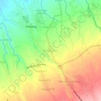
Name: Buna Cerca topographic map, elevation, terrain.

Location: Buna Cerca, Indang, Cavite, Calabarzon, 4122, Philippines (14.16654 120.86705 14.20654 120.90705)

Average elevation: 1,093 ft

Minimum elevation: 830 ft

Maximum elevation: 1,371 ft

Other topographic maps

Click on a map to view its topography, its elevation and its terrain.

Bancod

Philippines > Cavite > Indang

Average elevation: 791 ft

Mataas na Lupa (Checkpoint)

Philippines > Cavite > Indang

Average elevation: 738 ft

Kaytapos

Philippines > Cavite > Indang

Average elevation: 1,010 ft

Mataas na Lupa (Checkpoint)

Philippines > Cavite > Indang

Average elevation: 738 ft

Gear up for your next adventure:

🚑Emergency Bivvies - Heat-reflective sleeping bags for survival situations
⛑️Personal Locator Beacon - Safety beacon for emergencies
🌎3D Topographic Globes - Raised relief globes for a tactile understanding of geography
🩳Quick‑Dry Hiking Shorts - Comfortable and quick‑dry shorts for summer hiking
🏔️Mountain Trail Maps - High‑detail maps for popular peaks

As an Amazon Associate, this site earns from qualifying purchases at no extra cost to you.