Geolocate

Hopewell topographic map

Click on the map to display elevation.

About this map

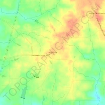
Name: Hopewell topographic map, elevation, terrain.

Location: Hopewell, Harris County, Georgia, United States (32.80263 -84.97410 32.84263 -84.93410)

Average elevation: 801 ft

Minimum elevation: 702 ft

Maximum elevation: 883 ft

Harris County trails, hiking, mountain biking, running and outdoor activities

Other topographic maps

Click on a map to view its topography, its elevation and its terrain.

Hamilton

United States > Georgia > Harris County

Average elevation: 810 ft

Shiloh

United States > Georgia > Harris County

Average elevation: 866 ft

Waverly Hall

United States > Georgia > Harris County

Average elevation: 712 ft

Whitesville

United States > Georgia > Harris County

Average elevation: 682 ft

Pine Mountain

United States > Georgia > Harris County

Average elevation: 899 ft

Gear up for your next adventure:

📖Nature Tracking Books - Learn to track wildlife and terrain
🧯Portable Fire Pit - Compact fire pit for camping spots
👟Trail Running Shoes - Lightweight shoes for trail runners
🎒Trail Energy Bars - High‑calorie bars for hiking energy
🔋Solar Power Banks - Keep your GPS and phone charged in remote wilderness areas

As an Amazon Associate, this site earns from qualifying purchases at no extra cost to you.