Geolocate

Apache topographic map

Click on the map to display elevation.

About this map

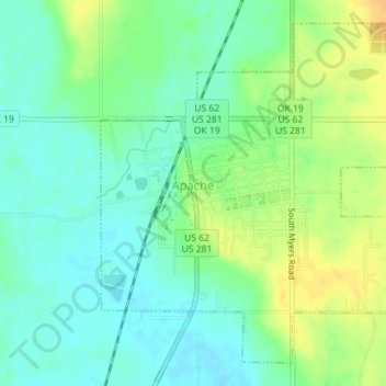
Name: Apache topographic map, elevation, terrain.

Location: Apache, Caddo County, Oklahoma, United States (34.88028 -98.37437 34.90589 -98.33898)

Average elevation: 1,280 ft

Minimum elevation: 1,240 ft

Maximum elevation: 1,339 ft

Caddo County trails, hiking, mountain biking, running and outdoor activities

Other topographic maps

Click on a map to view its topography, its elevation and its terrain.

Three-Way Corner

United States > Oklahoma > Caddo County

Average elevation: 1,532 ft

Indian City

United States > Oklahoma > Caddo County > Indian City

Average elevation: 1,266 ft

Washita

United States > Oklahoma > Caddo County > Washita

Average elevation: 1,253 ft

Gear up for your next adventure:

📖Nature Tracking Books - Learn to track wildlife and terrain
📦Dry Bags Set - Waterproof storage for electronics and clothes
💧Water Purification System - Clean water on the trail with reliable purifiers
🖼️Topo Map Wall Art - Decorative topographic prints of famous peaks and regions
🧥Waterproof Jacket for Hiking - Breathable and rugged rain jacket for outdoor excursions

As an Amazon Associate, this site earns from qualifying purchases at no extra cost to you.