
Tambillo topographic map
Interactive map
Click on the map to display elevation.
About this map
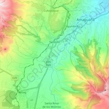
Name: Tambillo topographic map, elevation, terrain.
Location: Tambillo, Machachi, Pichincha, 171106, Ecuador (-0.46943 -78.61815 -0.37282 -78.48028)
Average elevation: 10,026 ft
Minimum elevation: 8,228 ft
Maximum elevation: 14,039 ft
Other topographic maps
Click on a map to view its topography, its elevation and its terrain.
Aloag Park
Ecuador > Pichincha > Machachi > Aloag
Aloag Park, Aloag, Machachi, Pichincha, 171108, Ecuador
Average elevation: 9,255 ft
Manuel Cornejo Astorga Tandapi
Ecuador > Pichincha > Machachi > Manuel Cornejo Astorga (Tandapi) > Manuel Cornejo Astorga Tandapi
Manuel Cornejo Astorga Tandapi, Manuel Cornejo Astorga (Tandapi), Machachi, Pichincha, Ecuador
Average elevation: 5,801 ft