
Make a donation
Gear up for your next adventure:
As an Amazon Associate, this site earns from qualifying purchases at no extra cost to you.
Municipio Revenga topographic map
Click on the map to display elevation.
Make a donation
Gear up for your next adventure:
As an Amazon Associate, this site earns from qualifying purchases at no extra cost to you.
About this map
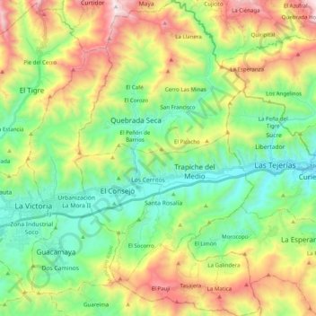
Name: Municipio Revenga topographic map, elevation, terrain.
Location: Municipio Revenga, Estado Aragua, 2118, Venezuela (10.15984 -67.29875 10.35437 -67.18270)
Average elevation: 3,110 ft
Minimum elevation: 1,499 ft
Maximum elevation: 6,125 ft
Make a donation
Gear up for your next adventure:
As an Amazon Associate, this site earns from qualifying purchases at no extra cost to you.
Other topographic maps
Click on a map to view its topography, its elevation and its terrain.
Colonia Tovar
Venezuela > Estado Aragua > Municipio Tovar
La Colonia Tovar es una ciudad venezolana, capital del Municipio Tovar, en el Estado Aragua. Fue fundada el 8 de abril de 1843 por un grupo de inmigrantes alemanes provenientes del entonces Gran Ducado de Baden (luego incorporado a Alemania). Se caracteriza por mantener la impronta cultural de su origen, por…
Average elevation: 3,540 ft