
Thank you for supporting this site ❤️
Make a donation
Make a donation
Gear up for your next adventure:
As an Amazon Associate, this site earns from qualifying purchases at no extra cost to you.
Rubengera topographic map
Click on the map to display elevation.
Thank you for supporting this site ❤️
Make a donation
Make a donation
Gear up for your next adventure:
As an Amazon Associate, this site earns from qualifying purchases at no extra cost to you.
About this map
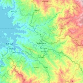
Name: Rubengera topographic map, elevation, terrain.
Location: Rubengera, Karongi, Western Province, Rwanda (-2.08678 29.31788 -2.02588 29.48153)
Average elevation: 6,004 ft
Minimum elevation: 4,767 ft
Maximum elevation: 8,576 ft
Thank you for supporting this site ❤️
Make a donation
Make a donation
Gear up for your next adventure:
As an Amazon Associate, this site earns from qualifying purchases at no extra cost to you.