
North Logan topographic map
Click on the map to display elevation.
About this map
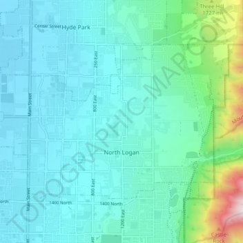
Name: North Logan topographic map, elevation, terrain.
Location: North Logan, Cache County, Utah, 84341, United States (41.75838 -111.84773 41.79492 -111.77082)
Average elevation: 4,879 ft
Minimum elevation: 4,446 ft
Maximum elevation: 7,215 ft
Cache County trails, hiking, mountain biking, running and outdoor activities
Other topographic maps
Click on a map to view its topography, its elevation and its terrain.
Logan Canyon
United States > Utah > Cache County
Logan Canyon is a canyon in the western United States in northeastern Utah, which cuts its way through the Bear River Mountains, a branch of the Wasatch Range. It is popular for both summer and winter activities, especially rock-climbing, hiking, camping, fishing, snowmobiling, and skiing, at the Beaver…
Average elevation: 5,840 ft