
Hatley Mountain topographic map
Interactive map
Click on the map to display elevation.
About this map
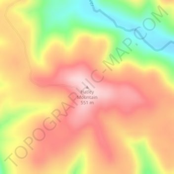
Name: Hatley Mountain topographic map, elevation, terrain.
Location: Hatley Mountain, Van Buren County, Arkansas, United States (35.56058 -92.76938 35.56068 -92.76928)
Average elevation: 1,460 ft
Minimum elevation: 961 ft
Maximum elevation: 1,808 ft
Other topographic maps
Click on a map to view its topography, its elevation and its terrain.
Fairfield Bay
United States > Arkansas > Van Buren County
Fairfield Bay, Van Buren County, Arkansas, 72088, United States
Average elevation: 755 ft
Shirley
United States > Arkansas > Van Buren County
Shirley, Van Buren County, Arkansas, 72153, United States
Average elevation: 673 ft
Shirley
United States > Arkansas > Van Buren County > Shirley > Shirley
Shirley, Van Buren County, Arkansas, 72153, United States
Average elevation: 699 ft
Clinton
United States > Arkansas > Van Buren County
Clinton, Van Buren County, Arkansas, 72031, United States
Average elevation: 755 ft
Botkinburg
United States > Arkansas > Van Buren County > Botkinburg
Botkinburg, Van Buren County, Arkansas, 72629, United States
Average elevation: 1,243 ft
Bee Branch
United States > Arkansas > Van Buren County
Bee Branch, Van Buren County, Arkansas, 72013, United States
Average elevation: 823 ft