Geolocate

Bee Branch topographic map

Click on the map to display elevation.

About this map

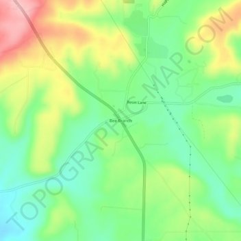
Name: Bee Branch topographic map, elevation, terrain.

Location: Bee Branch, Van Buren County, Arkansas, 72013, United States (35.43091 -92.41460 35.47091 -92.37460)

Average elevation: 823 ft

Minimum elevation: 610 ft

Maximum elevation: 1,148 ft

Van Buren County trails, hiking, mountain biking, running and outdoor activities

Other topographic maps

Click on a map to view its topography, its elevation and its terrain.

Fairfield Bay

United States > Arkansas > Van Buren County

Average elevation: 755 ft

Clinton

United States > Arkansas > Van Buren County

Average elevation: 755 ft

Shirley

United States > Arkansas > Van Buren County

Average elevation: 673 ft

Shirley

United States > Arkansas > Van Buren County

Average elevation: 673 ft

Clinton

United States > Arkansas > Van Buren County

Average elevation: 755 ft

Gear up for your next adventure:

🔭Compact Binoculars - HD vision for scouting terrain and identifying distant landmarks
🧦Merino Wool Socks - Moisture-wicking, blister-preventing socks for long treks
🗃️Trail First Aid Kit - Essential kit for outdoor injuries and emergencies
🧤Hiking Gloves - Protective gloves for rugged trails
❄️Traction Cleats - Prevent slips on icy trails during winter hikes

As an Amazon Associate, this site earns from qualifying purchases at no extra cost to you.