
Make a donation
Gear up for your next adventure:
As an Amazon Associate, this site earns from qualifying purchases at no extra cost to you.
Bahlā topographic map
Click on the map to display elevation.
Make a donation
Gear up for your next adventure:
As an Amazon Associate, this site earns from qualifying purchases at no extra cost to you.
About this map
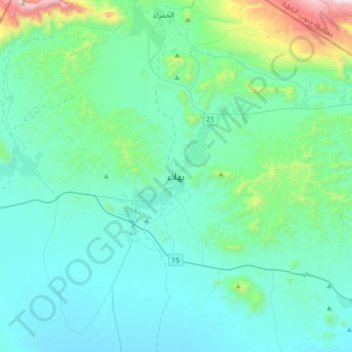
Name: Bahlā topographic map, elevation, terrain.
Location: Bahlā, Ad Dakhiliyah Governorate, 617, Oman (22.81003 57.13870 23.13003 57.45870)
Average elevation: 2,198 ft
Minimum elevation: 1,490 ft
Maximum elevation: 6,568 ft
Make a donation
Gear up for your next adventure:
As an Amazon Associate, this site earns from qualifying purchases at no extra cost to you.
Other topographic maps
Click on a map to view its topography, its elevation and its terrain.
Izki
Oman > Ad Dakhiliyah Governorate
Izki (Arabic: إِزْكِي) is a town in the region Ad Dakhiliyah, northeastern Oman. It is located at c. 544 m (1,785 ft) altitude, and has a population of 35,173 (2003 census).
Average elevation: 2,172 ft