
Make a donation
Gear up for your next adventure:
As an Amazon Associate, this site earns from qualifying purchases at no extra cost to you.
Kravaalbos topographic map
Click on the map to display elevation.
Make a donation
Gear up for your next adventure:
As an Amazon Associate, this site earns from qualifying purchases at no extra cost to you.
Kravaalbos
Het landschap van het bos vertoont duidelijk tekenen van het heuvelland tussen Aalst en Brussel. Zo ligt het hoogste punt om en bij de 80 meter boven zeeniveau, en is er een hoogte-interval van ongeveer 50 meter. Het bos sluit aan op het Natuurpunt-reservaat 'Kravaalvelden' (grasland, hakhoutbos, elzenbroek met wilde hop). Het Kravaalbos is Europees beschermd als onderdeel van Natura 2000-habitatrichtlijngebied (Bossen van de Vlaamse Ardennen en andere Zuid-Vlaamse bossen).
Make a donation
Gear up for your next adventure:
As an Amazon Associate, this site earns from qualifying purchases at no extra cost to you.
About this map
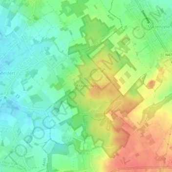
Name: Kravaalbos topographic map, elevation, terrain.
Average elevation: 167 ft
Minimum elevation: 92 ft
Maximum elevation: 269 ft
Make a donation
Gear up for your next adventure:
As an Amazon Associate, this site earns from qualifying purchases at no extra cost to you.