
Make a donation
Gear up for your next adventure:
As an Amazon Associate, this site earns from qualifying purchases at no extra cost to you.
Albatàrrec topographic map
Click on the map to display elevation.
Make a donation
Gear up for your next adventure:
As an Amazon Associate, this site earns from qualifying purchases at no extra cost to you.
About this map
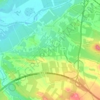
Name: Albatàrrec topographic map, elevation, terrain.
Location: Albatàrrec, Segriá, Lérida, Cataluña, 25171, España (41.54451 0.59070 41.58301 0.64352)
Average elevation: 525 ft
Minimum elevation: 410 ft
Maximum elevation: 719 ft
Make a donation
Gear up for your next adventure:
As an Amazon Associate, this site earns from qualifying purchases at no extra cost to you.
Other topographic maps
Click on a map to view its topography, its elevation and its terrain.
Alcoletge
El relieve del territorio es predominantemente llano y se extiende desde el sector nororiental de la llanura del Segrià, en la margen izquierda del río Segre, que hace de límite con Corbíns, hasta la Plana de Urgel. La altitud del municipio oscila entre los 242 metros en un cerro pegado al casco urbano y…
Average elevation: 610 ft
Make a donation
Gear up for your next adventure:
As an Amazon Associate, this site earns from qualifying purchases at no extra cost to you.
Santa Maria de Gimenells
España > Cataluña > Segriá > Gimenells i el Pla de la Font > Santa Maria de Gimenells
Average elevation: 846 ft
Make a donation
Gear up for your next adventure:
As an Amazon Associate, this site earns from qualifying purchases at no extra cost to you.