Geolocate

Aboke topographic map

Click on the map to display elevation.

About this map

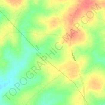
Name: Aboke topographic map, elevation, terrain.

Location: Aboke, Atiba, Oyo State, Nigeria (7.96333 3.88000 8.00333 3.92000)

Average elevation: 961 ft

Minimum elevation: 860 ft

Maximum elevation: 1,053 ft

Gear up for your next adventure:

🏥Hiking First Aid Kits - Comprehensive medical kits for remote trail injuries
🦟Ultrasonic Repellers - Create a bug-free zone at your camp or rest stop
🪶Thermal Camp Blanket - Extra warmth for cold nights
🚁Photography Drones - Capture stunning aerial views of landforms and topography
🥾Hiking Shoes - Durable and comfortable shoes for trail hiking

As an Amazon Associate, this site earns from qualifying purchases at no extra cost to you.