
Thank you for supporting this site ❤️
Make a donation
Make a donation
Gear up for your next adventure:
As an Amazon Associate, this site earns from qualifying purchases at no extra cost to you.
Bistrița topographic map
Click on the map to display elevation.
Thank you for supporting this site ❤️
Make a donation
Make a donation
Gear up for your next adventure:
As an Amazon Associate, this site earns from qualifying purchases at no extra cost to you.
About this map
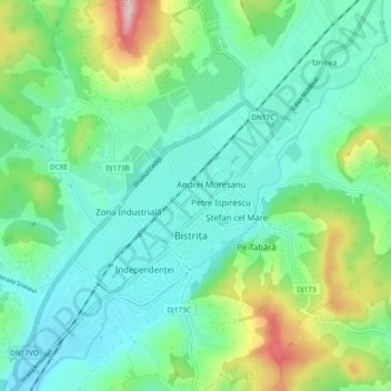
Name: Bistrița topographic map, elevation, terrain.
Location: Bistrița, Bistrița-Năsăud, Romania (47.10717 24.45271 47.17116 24.54194)
Average elevation: 1,368 ft
Minimum elevation: 1,112 ft
Maximum elevation: 2,156 ft
Thank you for supporting this site ❤️
Make a donation
Make a donation
Gear up for your next adventure:
As an Amazon Associate, this site earns from qualifying purchases at no extra cost to you.
Other topographic maps
Click on a map to view its topography, its elevation and its terrain.
Bistrița
Romania > Bistrița-Năsăud > Bistrița
Due to its modest elevation, Bistrița has one of the coldest climates in Romania.
Average elevation: 1,407 ft