
Make a donation
Gear up for your next adventure:
As an Amazon Associate, this site earns from qualifying purchases at no extra cost to you.
Bremersheide topographic map
Click on the map to display elevation.
Make a donation
Gear up for your next adventure:
As an Amazon Associate, this site earns from qualifying purchases at no extra cost to you.
Bremersheide
Bremersheide liegt östlich des Leichlinger Zentrums auf einem Höhenrücken zwischen dem Murbach und dem Weltersbach nördlich der Landesstraße 294 nahe der Stadtgrenze zu Leverkusen und zu Burscheid. Nördlich grenzt der Ort an das Naturschutzgebiet Weltersbachtal. In Bremersheide zweigt die Kreisstraße K6 nach Sankt Heribert ab.
Make a donation
Gear up for your next adventure:
As an Amazon Associate, this site earns from qualifying purchases at no extra cost to you.
About this map
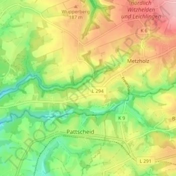
Name: Bremersheide topographic map, elevation, terrain.
Average elevation: 499 ft
Minimum elevation: 262 ft
Maximum elevation: 764 ft
Make a donation
Gear up for your next adventure:
As an Amazon Associate, this site earns from qualifying purchases at no extra cost to you.
Other topographic maps
Click on a map to view its topography, its elevation and its terrain.
42799
Deutschland > Nordrhein-Westfalen > Rheinisch-Bergischer Kreis > Leichlingen > Metzholz > Koltershäuschen
Average elevation: 469 ft