
Lansdowne topographic map
Click on the map to display elevation.
About this map
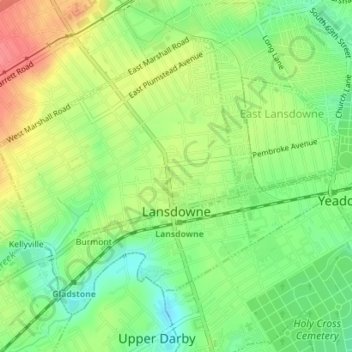
Name: Lansdowne topographic map, elevation, terrain.
Location: Lansdowne, Delaware County, Pennsylvania, United States (39.93026 -75.28974 39.95145 -75.26436)
Average elevation: 131 ft
Minimum elevation: 30 ft
Maximum elevation: 249 ft
Delaware County trails, hiking, mountain biking, running and outdoor activities
Other topographic maps
Click on a map to view its topography, its elevation and its terrain.
Pendle Hill
United States > Pennsylvania > Delaware County > Nether Providence Township
Average elevation: 200 ft
Chadds Ford Township
United States > Pennsylvania > Delaware County > Chadds Ford Township
Average elevation: 331 ft
Havertown
United States > Pennsylvania > Delaware County > Haverford Township
Average elevation: 276 ft
Villanova
United States > Pennsylvania > Delaware County > Radnor Township > Radnor
Average elevation: 390 ft
Newtown Square
United States > Pennsylvania > Delaware County > Newtown Township > Springton Pointe Woods
Average elevation: 387 ft
Garrett Hill
United States > Pennsylvania > Delaware County > Radnor Township > Radnor
Average elevation: 384 ft
Upper Providence
United States > Pennsylvania > Delaware County > Upper Providence Township
Average elevation: 325 ft
Booths Corner
United States > Pennsylvania > Delaware County > Bethel Township
Average elevation: 344 ft
Ithan
United States > Pennsylvania > Delaware County > Radnor Township > Saint Davids
Average elevation: 381 ft
Oakmont
United States > Pennsylvania > Delaware County > Haverford Township > Havertown
Average elevation: 305 ft
Glen Providence Park
United States > Pennsylvania > Delaware County > Upper Providence > Moylan
Average elevation: 249 ft
Riddlewood
United States > Pennsylvania > Delaware County > Middletown Township
Average elevation: 259 ft
Upper Providence
United States > Pennsylvania > Delaware County > Upper Providence Township
Average elevation: 325 ft
Radnor Station
United States > Pennsylvania > Delaware County > Radnor Township > Saint Davids
Average elevation: 390 ft
Newtown Square
United States > Pennsylvania > Delaware County > Newtown Township > Springton Pointe Woods
Average elevation: 387 ft
Moylan
United States > Pennsylvania > Delaware County > Upper Providence Township
Average elevation: 233 ft
Chadds Ford
United States > Pennsylvania > Delaware County > Chadds Ford Township
Average elevation: 282 ft
Villanova
United States > Pennsylvania > Delaware County > Radnor Township > Radnor
Average elevation: 390 ft
Moylan-Rose Valley Station
United States > Pennsylvania > Delaware County > Nether Providence Township
Average elevation: 213 ft
Havertown
United States > Pennsylvania > Delaware County > Haverford Township
Average elevation: 289 ft
Thornton
United States > Pennsylvania > Delaware County > Thornbury Township
Average elevation: 397 ft
Villanova
United States > Pennsylvania > Delaware County > Radnor Township > Radnor
Average elevation: 390 ft
Booths Corner
United States > Pennsylvania > Delaware County > Bethel Township
Average elevation: 344 ft
Wallingford
United States > Pennsylvania > Delaware County > Nether Providence Township
Average elevation: 135 ft
Broomall
United States > Pennsylvania > Delaware County > Marple Township > Broomall
Average elevation: 308 ft
Lapidea
United States > Pennsylvania > Delaware County > Nether Providence Township
Average elevation: 102 ft
West Ridley Park
United States > Pennsylvania > Delaware County > Ridley Township
Average elevation: 69 ft
Penfield
United States > Pennsylvania > Delaware County > Haverford Township
Average elevation: 256 ft
Saint Davids
United States > Pennsylvania > Delaware County > Radnor Township
Average elevation: 400 ft
Ward
United States > Pennsylvania > Delaware County > Concord Township > Ward
Average elevation: 341 ft
Kirklyn
United States > Pennsylvania > Delaware County > Upper Darby > Kirklyn
Average elevation: 230 ft