Geolocate

Bedford topographic map

Click on the map to display elevation.

About this map

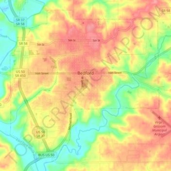
Name: Bedford topographic map, elevation, terrain.

Location: Bedford, Lawrence County, Indiana, 47421, United States (38.82550 -86.52635 38.88650 -86.43802)

Average elevation: 627 ft

Minimum elevation: 472 ft

Maximum elevation: 755 ft

Lawrence County trails, hiking, mountain biking, running and outdoor activities

Other topographic maps

Click on a map to view its topography, its elevation and its terrain.

Heltonville

United States > Indiana > Lawrence County

Average elevation: 738 ft

Thornton

United States > Indiana > Lawrence County

Average elevation: 571 ft

Fayetteville

United States > Indiana > Lawrence County

Average elevation: 659 ft

Hartleyville

United States > Indiana > Lawrence County

Average elevation: 607 ft

Bedford

United States > Indiana > Lawrence County > Bedford > Bedford

Average elevation: 620 ft

Gear up for your next adventure:

🎒Day Hiking Backpack - Lightweight backpack perfect for day trips and outdoor adventures
🥩Freeze-Dried Meals - Nutritious and lightweight food for remote expeditions
📶Satellite Messenger - Communication device off‑grid
🎒Hydration Pack - Hands‑free water reservoir for long hikes
🪓Survival Multi‑Tool - Versatile tool for camp and trail tasks

As an Amazon Associate, this site earns from qualifying purchases at no extra cost to you.