
Lighthouse Park topographic map
Click on the map to display elevation.
Lighthouse Park
The sword fern (Polystichum munitum), one of the most abundant ferns in North America, can be found from Alaska to California and is named for its small upward-pointing lobe that resembles a sword hilt. This fern prefers to grow in moist, coniferous low elevation environments but can survive dry periods. Traditionally, this plant has been eaten when no other food source was available, can relieve the pain from the sting of a stinging nettle but now it is mostly used by florists as an ornament.
About this map
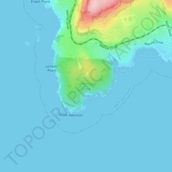
Name: Lighthouse Park topographic map, elevation, terrain.
Average elevation: 72 ft
Minimum elevation: 0 ft
Maximum elevation: 633 ft
Other topographic maps
Click on a map to view its topography, its elevation and its terrain.
Capilano Lake
Canada > British Columbia > Metro Vancouver Regional District > West Vancouver
Average elevation: 1,158 ft