
Make a donation
Gear up for your next adventure:
As an Amazon Associate, this site earns from qualifying purchases at no extra cost to you.
La Rivera topographic map
Click on the map to display elevation.
Make a donation
Gear up for your next adventure:
As an Amazon Associate, this site earns from qualifying purchases at no extra cost to you.
About this map
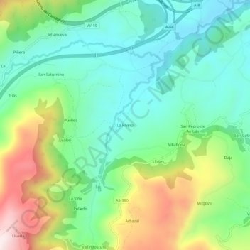
Name: La Rivera topographic map, elevation, terrain.
Location: La Rivera, Villaviciosa, Asturias, España (43.42642 -5.52096 43.46642 -5.48096)
Average elevation: 699 ft
Minimum elevation: 98 ft
Maximum elevation: 1,949 ft
Make a donation
Gear up for your next adventure:
As an Amazon Associate, this site earns from qualifying purchases at no extra cost to you.
Other topographic maps
Click on a map to view its topography, its elevation and its terrain.
Selorio
España > Asturias > Villaviciosa
La aldea de Selorio se sitúa en la zona central del término parroquial a una altitud de 25 metros, distando 9 km de la capital municipal. Es de creación moderna, por agrupación de los núcleos de La Ariella, La Barquera, La Calle, La Chispa, Misiego, El Olivar, El Pandal, La Piniella, Rodiles y Terienzo.…
Average elevation: 253 ft
Make a donation
Gear up for your next adventure:
As an Amazon Associate, this site earns from qualifying purchases at no extra cost to you.
Tazones
España > Asturias > Villaviciosa
Se sitúa en la Punta del Olivo o de las Ariceras, a una altitud de 127 metros sobre el nivel del mar y 11 sobre el terreno, en un recinto ajardinado de 2000 metros cuadrados, cerrado con muro de piedra con lajas de pizarra en la parte superior.
Average elevation: 246 ft