Geolocate

Riggs topographic map

Click on the map to display elevation.

About this map

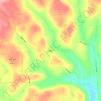
Name: Riggs topographic map, elevation, terrain.

Location: Riggs, Bradford County, Pennsylvania, United States (41.81813 -76.59606 41.85813 -76.55606)

Average elevation: 1,276 ft

Minimum elevation: 997 ft

Maximum elevation: 1,512 ft

Bradford County trails, hiking, mountain biking, running and outdoor activities

Other topographic maps

Click on a map to view its topography, its elevation and its terrain.

Sayre

United States > Pennsylvania > Bradford County

Average elevation: 823 ft

Towanda

United States > Pennsylvania > Bradford County

Average elevation: 912 ft

Le Raysville

United States > Pennsylvania > Bradford County

Average elevation: 1,388 ft

Alba

United States > Pennsylvania > Bradford County

Average elevation: 1,483 ft

Burlington

United States > Pennsylvania > Bradford County

Average elevation: 1,063 ft

Monroe

United States > Pennsylvania > Bradford County

Average elevation: 915 ft

Sylvania

United States > Pennsylvania > Bradford County

Average elevation: 1,453 ft

Wyalusing

United States > Pennsylvania > Bradford County

Average elevation: 768 ft

Pike Township

United States > Pennsylvania > Bradford County

Average elevation: 1,332 ft

Gear up for your next adventure:

🌧️Backpack Rain Cover - Keep gear dry in wet weather
🎒Waterproof Dry Bags - Keep your electronics and maps dry inside your pack
🦺Reflective Outdoor Gear - Safety gear for low‑light conditions
☀️Outdoor Sunscreen - High protection sunscreen for outdoor activities
🧴Hand Sanitizer - Keep hands clean while hiking

As an Amazon Associate, this site earns from qualifying purchases at no extra cost to you.