Geolocate

Columbus topographic map

Click on the map to display elevation.

About this map

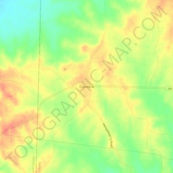
Name: Columbus topographic map, elevation, terrain.

Location: Columbus, Hempstead County, Arkansas, 71831, United States (33.75595 -93.83713 33.79595 -93.79713)

Average elevation: 404 ft

Minimum elevation: 312 ft

Maximum elevation: 476 ft

Hempstead County trails, hiking, mountain biking, running and outdoor activities

Other topographic maps

Click on a map to view its topography, its elevation and its terrain.

Perrytown

United States > Arkansas > Hempstead County

Average elevation: 302 ft

Blevins

United States > Arkansas > Hempstead County

Average elevation: 413 ft

Oakhaven

United States > Arkansas > Hempstead County

Average elevation: 354 ft

McCaskill

United States > Arkansas > Hempstead County

Average elevation: 430 ft

Patmos

United States > Arkansas > Hempstead County

Average elevation: 335 ft

Ozan

United States > Arkansas > Hempstead County

Average elevation: 367 ft

Gear up for your next adventure:

🗺️NatGeo Topo Maps - High-quality waterproof printed topographic maps of US Parks
👟Men's Trail Runners - Lightweight footwear for fast-paced exploration and light hiking
🏥Hiking First Aid Kits - Comprehensive medical kits for remote trail injuries
🍳Camping Cook Set - Complete cookware for outdoor meals
📦Dry Bags Set - Waterproof storage for electronics and clothes

As an Amazon Associate, this site earns from qualifying purchases at no extra cost to you.