
Make a donation
Gear up for your next adventure:
As an Amazon Associate, this site earns from qualifying purchases at no extra cost to you.
Saint-Aubin (FR) topographic map
Click on the map to display elevation.
Make a donation
Gear up for your next adventure:
As an Amazon Associate, this site earns from qualifying purchases at no extra cost to you.
About this map
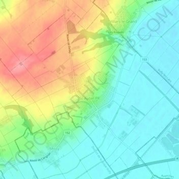
Name: Saint-Aubin (FR) topographic map, elevation, terrain.
Location: Saint-Aubin (FR), District de la Broye, Fribourg, 1566, Suisse (46.87584 6.95660 46.90772 7.00951)
Average elevation: 1,526 ft
Minimum elevation: 1,407 ft
Maximum elevation: 1,736 ft
Make a donation
Gear up for your next adventure:
As an Amazon Associate, this site earns from qualifying purchases at no extra cost to you.
Other topographic maps
Click on a map to view its topography, its elevation and its terrain.
Vigny
Suisse > Fribourg > District de la Broye > Belmont-Broye > Léchelles
Average elevation: 1,903 ft
Montagny-les-Monts
Suisse > Fribourg > District de la Broye > Montagny (FR)
Average elevation: 1,886 ft
Make a donation
Gear up for your next adventure:
As an Amazon Associate, this site earns from qualifying purchases at no extra cost to you.
Make a donation
Gear up for your next adventure:
As an Amazon Associate, this site earns from qualifying purchases at no extra cost to you.
Cousset
Suisse > Fribourg > District de la Broye > Montagny (FR) > Cousset
Average elevation: 1,729 ft
Make a donation
Gear up for your next adventure:
As an Amazon Associate, this site earns from qualifying purchases at no extra cost to you.
Les Carrons
Suisse > Fribourg > District de la Broye > Cheyres-Châbles > Châbles FR
Average elevation: 1,713 ft