
Make a donation
Gear up for your next adventure:
As an Amazon Associate, this site earns from qualifying purchases at no extra cost to you.
Longarone topographic map
Click on the map to display elevation.
Make a donation
Gear up for your next adventure:
As an Amazon Associate, this site earns from qualifying purchases at no extra cost to you.
About this map
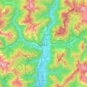
Name: Longarone topographic map, elevation, terrain.
Location: Longarone, Belluno, Veneto, 32013, Italië (46.21432 12.15205 46.32230 12.37237)
Average elevation: 3,976 ft
Minimum elevation: 1,240 ft
Maximum elevation: 8,586 ft
Make a donation
Gear up for your next adventure:
As an Amazon Associate, this site earns from qualifying purchases at no extra cost to you.
Other topographic maps
Click on a map to view its topography, its elevation and its terrain.
Passo Falzarego
Italië > Veneto > Belluno > Cortina d'Ampezzo > Passo Falzarego
De pashoogte van de Falzarego wordt gedomineerd door de Monte Lagozuoi. Vanaf de pas gaat een kabelbaan omhoog naar deze 2802 meter hoge top. In noordelijke richting gaat de weg naar de nabije Valparolapas. Het uitzicht op de Marmolada en de berggroep Cinque Torri is van hieruit goed.
Average elevation: 7,149 ft
Make a donation
Gear up for your next adventure:
As an Amazon Associate, this site earns from qualifying purchases at no extra cost to you.
Drei Zinnen
Italië > Veneto > Belluno > Auronzo di Cadore
Pas in 1933 slaagde er iemand in de Cima Grande ook via de noordkant te beklimmen, en dat was de Italiaanse legendarische bergbeklimmer Emilio Comici. De beklimming hiervan staat bekend als een hoogtepunt in de geschiedenis van de klimsport en werd de eerste beklimming die de moeilijkheidsgraad VI meekreeg.
Average elevation: 7,356 ft
Make a donation
Gear up for your next adventure:
As an Amazon Associate, this site earns from qualifying purchases at no extra cost to you.
Make a donation
Gear up for your next adventure:
As an Amazon Associate, this site earns from qualifying purchases at no extra cost to you.
Make a donation
Gear up for your next adventure:
As an Amazon Associate, this site earns from qualifying purchases at no extra cost to you.
Make a donation
Gear up for your next adventure:
As an Amazon Associate, this site earns from qualifying purchases at no extra cost to you.
Cortina d'Ampezzo
Italië > Veneto > Belluno > Cortina d'Ampezzo > Cortina d'Ampezzo
Cortina d'Ampezzo (Ladinisch: Anpëz of Anpezo, Duits: Hayden) is een plaats in de Italiaanse regio Veneto in de provincie Belluno. Cortina d'Ampezzo ligt in de nabijheid van enkele bekende bergpassen, zoals de Falzarego, Valparola, Giau en Tre Croci. 's Winters blijven deze ondanks de hoogte geopend om de…
Average elevation: 5,410 ft
Make a donation
Gear up for your next adventure:
As an Amazon Associate, this site earns from qualifying purchases at no extra cost to you.