
Make a donation
Gear up for your next adventure:
As an Amazon Associate, this site earns from qualifying purchases at no extra cost to you.
Le Trioulou topographic map
Click on the map to display elevation.
Make a donation
Gear up for your next adventure:
As an Amazon Associate, this site earns from qualifying purchases at no extra cost to you.
About this map
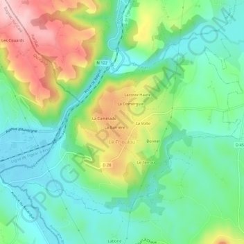
Name: Le Trioulou topographic map, elevation, terrain.
Average elevation: 1,001 ft
Minimum elevation: 748 ft
Maximum elevation: 1,486 ft
Make a donation
Gear up for your next adventure:
As an Amazon Associate, this site earns from qualifying purchases at no extra cost to you.
Other topographic maps
Click on a map to view its topography, its elevation and its terrain.
Make a donation
Gear up for your next adventure:
As an Amazon Associate, this site earns from qualifying purchases at no extra cost to you.
Les Trois Pierres
France > Auvergne-Rhône-Alpes > Cantal > Albepierre-Bredons
Average elevation: 4,019 ft
Make a donation
Gear up for your next adventure:
As an Amazon Associate, this site earns from qualifying purchases at no extra cost to you.
La Roche
France > Auvergne-Rhône-Alpes > Cantal > Val d'Arcomie > Saint-Marc
Average elevation: 3,130 ft