
Thank you for supporting this site ❤️
Make a donation
Make a donation
Gear up for your next adventure:
As an Amazon Associate, this site earns from qualifying purchases at no extra cost to you.
Ziswil topographic map
Click on the map to display elevation.
Thank you for supporting this site ❤️
Make a donation
Make a donation
Gear up for your next adventure:
As an Amazon Associate, this site earns from qualifying purchases at no extra cost to you.
About this map
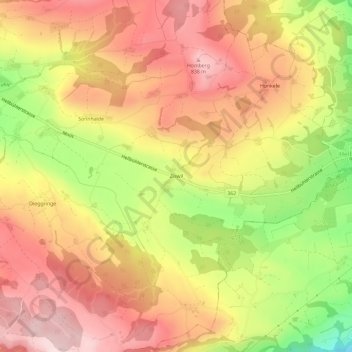
Name: Ziswil topographic map, elevation, terrain.
Location: Ziswil, Ruswil, Luzern, 6016, Schweiz (47.04823 8.14782 47.08823 8.18782)
Average elevation: 2,365 ft
Minimum elevation: 1,719 ft
Maximum elevation: 2,799 ft
Thank you for supporting this site ❤️
Make a donation
Make a donation
Gear up for your next adventure:
As an Amazon Associate, this site earns from qualifying purchases at no extra cost to you.