Make a donation
Gear up for your next adventure:
As an Amazon Associate, this site earns from qualifying purchases at no extra cost to you.
Hintertux topographic map
Click on the map to display elevation.
Make a donation
Gear up for your next adventure:
As an Amazon Associate, this site earns from qualifying purchases at no extra cost to you.
About this map
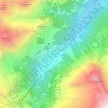
Name: Hintertux topographic map, elevation, terrain.
Location: Hintertux, Tux, Bezirk Schwaz, 6294, Austria (47.09502 11.66250 47.13502 11.70250)
Average elevation: 6,394 ft
Minimum elevation: 4,501 ft
Maximum elevation: 9,475 ft
Make a donation
Gear up for your next adventure:
As an Amazon Associate, this site earns from qualifying purchases at no extra cost to you.
Other topographic maps
Click on a map to view its topography, its elevation and its terrain.
Make a donation
Gear up for your next adventure:
As an Amazon Associate, this site earns from qualifying purchases at no extra cost to you.
Make a donation
Gear up for your next adventure:
As an Amazon Associate, this site earns from qualifying purchases at no extra cost to you.
Make a donation
Gear up for your next adventure:
As an Amazon Associate, this site earns from qualifying purchases at no extra cost to you.
Gerlos
Austria > Tyrol > Bezirk Schwaz
Gerlos is located in the de:Gerlostal, which is a side valley of the Zillertal, branching to the east near Zell am Ziller. Gerlos consists of several hamulated located along the de:Gerlospass on the floor of the valley, at an altitude of around 1200m. To the south, the side valleys of de:Schwarzach,…
Average elevation: 6,270 ft
