Geolocate

Kempner topographic map

Click on the map to display elevation.

About this map

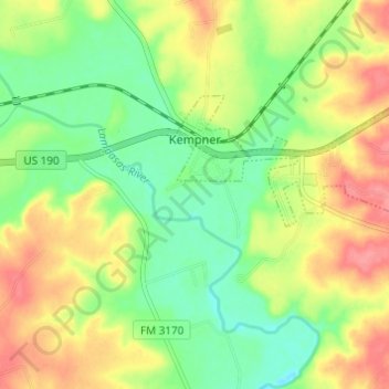
Name: Kempner topographic map, elevation, terrain.

Location: Kempner, Lampasas County, Texas, United States (31.06028 -98.00566 31.08685 -97.94480)

Average elevation: 919 ft

Minimum elevation: 801 ft

Maximum elevation: 1,060 ft

Lampasas County trails, hiking, mountain biking, running and outdoor activities

Other topographic maps

Click on a map to view its topography, its elevation and its terrain.

Adamsville

United States > Texas > Lampasas County

Average elevation: 1,102 ft

Big Thicket

United States > Texas > Lampasas County

Average elevation: 1,234 ft

Gear up for your next adventure:

🛡️Bear Spray Outdoor - Protection in bear country hikes
Backpacking Tent - Lightweight and durable tent for multi‑day hikes
📱Solar Portable Charger - Solar power bank for charging devices off‑grid
🔭Compact Binoculars - HD vision for scouting terrain and identifying distant landmarks
🧭Map Reading Tools - Tools and kits for map navigation

As an Amazon Associate, this site earns from qualifying purchases at no extra cost to you.