
Mount Graham topographic map
Click on the map to display elevation.
About this map
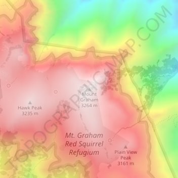
Name: Mount Graham topographic map, elevation, terrain.
Location: Mount Graham, Graham County, Arizona, United States (32.70159 -109.87144 32.70169 -109.87134)
Average elevation: 9,701 ft
Minimum elevation: 8,025 ft
Maximum elevation: 10,696 ft
Graham County trails, hiking, mountain biking, running and outdoor activities
Other topographic maps
Click on a map to view its topography, its elevation and its terrain.
Swift Trail Junction
United States > Arizona > Graham County
Swift Trail Junction is a census-designated place (CDP) in Graham County, Arizona, United States. The population was 2,935 at the 2010 census, up from 2,195 in 2000. It is part of the Safford Micropolitan Statistical Area. It is situated at the junction of U.S. Route 191 and State Route 366 (also known as the…
Average elevation: 3,228 ft