
Make a donation
Gear up for your next adventure:
As an Amazon Associate, this site earns from qualifying purchases at no extra cost to you.
Laar topographic map
Click on the map to display elevation.
Make a donation
Gear up for your next adventure:
As an Amazon Associate, this site earns from qualifying purchases at no extra cost to you.
Laar
Laar ligt in Droog-Haspengouw op een hoogte van 49-81 meter.
Make a donation
Gear up for your next adventure:
As an Amazon Associate, this site earns from qualifying purchases at no extra cost to you.
About this map
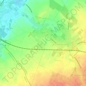
Name: Laar topographic map, elevation, terrain.
Location: Laar, Landen, Leuven, Vlaams-Brabant, Vlaanderen, België (50.75111 5.00335 50.78121 5.03488)
Average elevation: 213 ft
Minimum elevation: 131 ft
Maximum elevation: 292 ft
Make a donation
Gear up for your next adventure:
As an Amazon Associate, this site earns from qualifying purchases at no extra cost to you.
Other topographic maps
Click on a map to view its topography, its elevation and its terrain.