
Make a donation
Gear up for your next adventure:
As an Amazon Associate, this site earns from qualifying purchases at no extra cost to you.
Clouse Hill topographic map
Click on the map to display elevation.
Make a donation
Gear up for your next adventure:
As an Amazon Associate, this site earns from qualifying purchases at no extra cost to you.
About this map
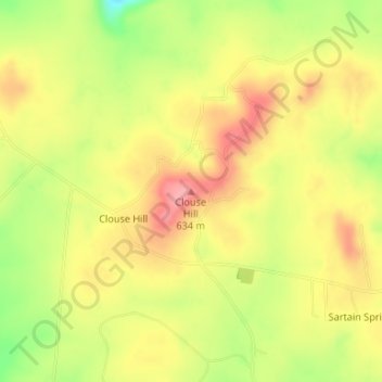
Name: Clouse Hill topographic map, elevation, terrain.
Location: Clouse Hill, Grundy County, Tennessee, United States (35.29364 -85.79558 35.29374 -85.79548)
Average elevation: 1,955 ft
Minimum elevation: 1,759 ft
Maximum elevation: 2,093 ft
Grundy County trails, hiking, mountain biking, running and outdoor activities
Make a donation
Gear up for your next adventure:
As an Amazon Associate, this site earns from qualifying purchases at no extra cost to you.
Other topographic maps
Click on a map to view its topography, its elevation and its terrain.
South Cumberland Recreation Area
United States > Tennessee > Grundy County > Beersheba Springs
Average elevation: 1,749 ft