Geolocate

Window Rock topographic map

Click on the map to display elevation.

Window Rock

Window Rock is categorized as being within the 6a USDA hardiness zone, meaning the average annual extreme minimum temperature is between −10 and −5 °F (−23 and −21 °C). The city is cooler than most of Arizona due to its high elevation.

Wikipedia (CC-BY-SA 3.0)

About this map

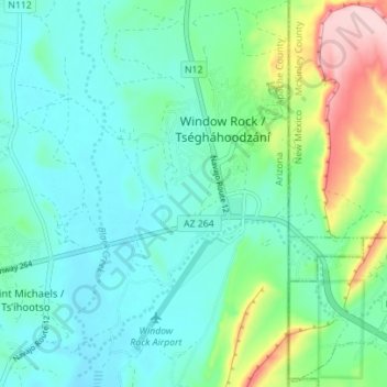
Name: Window Rock topographic map, elevation, terrain.

Location: Window Rock, Fort Defiance Agency, Apache County, Arizona, United States (35.63842 -109.08296 35.69518 -109.04622)

Average elevation: 6,837 ft

Minimum elevation: 6,673 ft

Maximum elevation: 7,372 ft

Apache County trails, hiking, mountain biking, running and outdoor activities

Other topographic maps

Click on a map to view its topography, its elevation and its terrain.

East Mesa

United States > Arizona > Apache County

Average elevation: 6,867 ft

Sanders

United States > Arizona > Apache County

Average elevation: 5,909 ft

Concho

United States > Arizona > Apache County

Average elevation: 6,050 ft

Fort Defiance

United States > Arizona > Apache County

Average elevation: 6,988 ft

Spider Rock

United States > Arizona > Apache County

Average elevation: 6,411 ft

Greer

United States > Arizona > Apache County

Average elevation: 8,757 ft

Lupton

United States > Arizona > Apache County

Average elevation: 6,371 ft

Chambers

United States > Arizona > Apache County

Average elevation: 5,827 ft

Vernon

United States > Arizona > Apache County

Average elevation: 6,952 ft

Many Farms

United States > Arizona > Apache County

Average elevation: 5,384 ft

Red Hill

United States > Arizona > Apache County

Average elevation: 6,004 ft

Red Rock

United States > Arizona > Apache County

Average elevation: 5,840 ft

Sawmill

United States > Arizona > Apache County

Average elevation: 7,723 ft

Red Rock

United States > Arizona > Apache County

Average elevation: 5,840 ft

Vernon

United States > Arizona > Apache County

Average elevation: 6,952 ft

Lukachukai

United States > Arizona > Apache County

Average elevation: 6,575 ft

Chinle

United States > Arizona > Apache County > Chinle

Average elevation: 5,627 ft

Nutrioso

United States > Arizona > Apache County

Average elevation: 7,887 ft

Toyei

United States > Arizona > Apache County

Average elevation: 6,539 ft

Concho

United States > Arizona > Apache County

Average elevation: 6,050 ft

Michigan Lake

United States > Arizona > Apache County

Average elevation: 6,194 ft

St. Michaels

United States > Arizona > Apache County

Average elevation: 6,778 ft

Concho

United States > Arizona > Apache County > Concho

Average elevation: 6,050 ft

Eagle Crag

United States > Arizona > Apache County

Average elevation: 6,463 ft

Red Rock

United States > Arizona > Apache County

Average elevation: 5,840 ft

Gear up for your next adventure:

Backpacking Tents - Weight-optimized shelters for multi-day topographic surveys
🛌Ultralight Sleeping Bags - Compact down bags for cold nights in the wilderness
🛡️Bear Spray Outdoor - Protection in bear country hikes
📦Dry Bags Set - Waterproof storage for electronics and clothes
🧼Biodegradable Camping Soap - Eco‑friendly soap for outdoor hygiene

As an Amazon Associate, this site earns from qualifying purchases at no extra cost to you.