
Make a donation
Gear up for your next adventure:
As an Amazon Associate, this site earns from qualifying purchases at no extra cost to you.
Wulpen topographic map
Click on the map to display elevation.
Make a donation
Gear up for your next adventure:
As an Amazon Associate, this site earns from qualifying purchases at no extra cost to you.
Wulpen
Wulpen ligt in het West-Vlaams poldergebied op een hoogte van ongeveer 2 meter. Ten noorden van Wulpen strekt zich een golfterrein uit. Wulpen ligt nabij het Kanaal Nieuwpoort-Duinkerke.
Make a donation
Gear up for your next adventure:
As an Amazon Associate, this site earns from qualifying purchases at no extra cost to you.
About this map
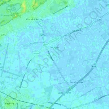
Name: Wulpen topographic map, elevation, terrain.
Location: Wulpen, Koksijde, Veurne, West-Vlaanderen, Vlaanderen, België (51.08128 2.66193 51.11397 2.75148)
Average elevation: 3 ft
Minimum elevation: -7 ft
Maximum elevation: 43 ft
Make a donation
Gear up for your next adventure:
As an Amazon Associate, this site earns from qualifying purchases at no extra cost to you.
Other topographic maps
Click on a map to view its topography, its elevation and its terrain.