
Make a donation
Gear up for your next adventure:
As an Amazon Associate, this site earns from qualifying purchases at no extra cost to you.
Berkholz topographic map
Click on the map to display elevation.
Make a donation
Gear up for your next adventure:
As an Amazon Associate, this site earns from qualifying purchases at no extra cost to you.
About this map
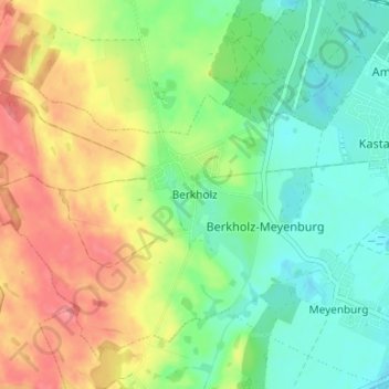
Name: Berkholz topographic map, elevation, terrain.
Average elevation: 125 ft
Minimum elevation: 23 ft
Maximum elevation: 269 ft
Make a donation
Gear up for your next adventure:
As an Amazon Associate, this site earns from qualifying purchases at no extra cost to you.
Other topographic maps
Click on a map to view its topography, its elevation and its terrain.
Make a donation
Gear up for your next adventure:
As an Amazon Associate, this site earns from qualifying purchases at no extra cost to you.
Kummerow
Deutschland > Brandenburg > Uckermark > Schwedt/Oder
Auf einer Anhöhe wurde hier in den 1970er Jahren eine vollständig erhaltene Graburne mit dem dazugehörigen Leichenbrand, den Resten von zwei Beigefäßen und dem Eisenschmuck gefunden. Die Urne entstammt der Eisenzeit (600 v. Chr. bis 0) und kam nach Angermünde ins Museum. Bis 1945 war Kummerow ein…
Average elevation: 82 ft