
Poggio San Lorenzo topographic map
Interactive map
Click on the map to display elevation.
About this map
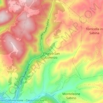
Name: Poggio San Lorenzo topographic map, elevation, terrain.
Location: Poggio San Lorenzo, Rieti, Lazio, Italy (42.22626 12.82102 42.27711 12.86254)
Average elevation: 1,683 ft
Minimum elevation: 830 ft
Maximum elevation: 2,457 ft
Other topographic maps
Click on a map to view its topography, its elevation and its terrain.
Monticchio
Italy > Lazio > Rieti > Monte San Giovanni in Sabina
Monticchio, Monte San Giovanni in Sabina, Rieti, Lazio, 02040, Italy
Average elevation: 2,552 ft
Poggio Fidoni
Poggio Fidoni, Rieti, Lazio, 02043, Italy
Average elevation: 1,827 ft
Pian de' Valli
Pian de' Valli, Rieti, Lazio, Italy
Average elevation: 5,016 ft
Contigliano
Italy > Lazio > Rieti > Contigliano
Contigliano, Rieti, Lazio, 02043, Italy
Average elevation: 1,995 ft
Stimigliano
Italy > Lazio > Rieti > Stimigliano
Stimigliano, Rieti, Lazio, 02048, Italy
Average elevation: 282 ft