Geolocate

Contigliano topographic map

Click on the map to display elevation.

About this map

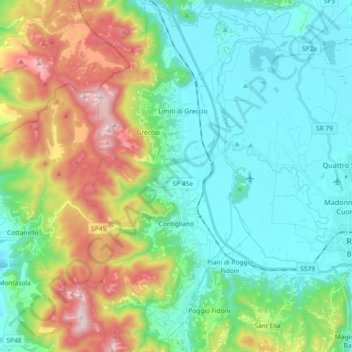
Name: Contigliano topographic map, elevation, terrain.

Location: Contigliano, Rieti, Lazio, 02043, Italy (42.35796 12.71602 42.49574 12.81261)

Average elevation: 1,995 ft

Minimum elevation: 1,148 ft

Maximum elevation: 4,108 ft

Other topographic maps

Click on a map to view its topography, its elevation and its terrain.

Terria

Italy > Lazio > Rieti > Contigliano

Average elevation: 1,283 ft

Gear up for your next adventure:

🔪Outdoor Multitools - Essential survival tools for gear repair and field use
🧯Emergency Survival Kit - All‑in‑one survival essentials for the backcountry
📖Nature Tracking Books - Learn to track wildlife and terrain
🧣Merino Neck Gaiters - Multi-functional headwear for wind and sun protection
Backpacking Tents - Weight-optimized shelters for multi-day topographic surveys

As an Amazon Associate, this site earns from qualifying purchases at no extra cost to you.