
Town of Erin topographic map
Interactive map
Click on the map to display elevation.
About this map
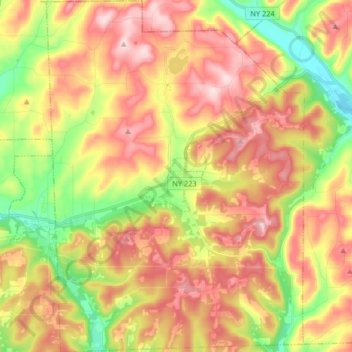
Name: Town of Erin topographic map, elevation, terrain.
Location: Town of Erin, Chemung County, New York, 14838, United States (42.12747 -76.73043 42.24839 -76.61058)
Average elevation: 1,470 ft
Minimum elevation: 1,001 ft
Maximum elevation: 1,896 ft
Chemung County trails, hiking, mountain biking, running and outdoor activities
Other topographic maps
Click on a map to view its topography, its elevation and its terrain.