
Lake Chelan Hills topographic map
Interactive map
Click on the map to display elevation.
About this map
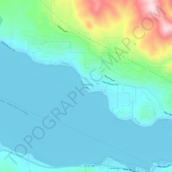
Name: Lake Chelan Hills topographic map, elevation, terrain.
Average elevation: 1,378 ft
Minimum elevation: 1,079 ft
Maximum elevation: 2,641 ft
Chelan County trails, hiking, mountain biking, running and outdoor activities
Other topographic maps
Click on a map to view its topography, its elevation and its terrain.
Lake Chelan
United States > Washington > Chelan County > Chelan
Lake Chelan (/ʃəˈlæn/ shə-LAN) is a narrow, 50.5 mi (81.3 km) long lake in Chelan County, north-central Washington state, U.S. It is an overdeepened lake and resembles a fjord, with an average width of 1.3 mi (2.1 km). Near its upper end, the lake surface lies more than 6,600 ft (2,000 m) below peaks less…
Average elevation: 4,455 ft