
Thank you for supporting this site ❤️
Make a donation
Make a donation
Gear up for your next adventure:
As an Amazon Associate, this site earns from qualifying purchases at no extra cost to you.
Madmaheshwar topographic map
Click on the map to display elevation.
Thank you for supporting this site ❤️
Make a donation
Make a donation
Gear up for your next adventure:
As an Amazon Associate, this site earns from qualifying purchases at no extra cost to you.
About this map
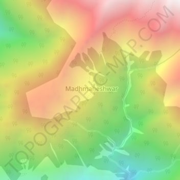
Name: Madmaheshwar topographic map, elevation, terrain.
Location: Madmaheshwar, Ukhimath, Rudraprayag, Uttarakhand, India (30.63352 79.22085 30.63552 79.22197)
Average elevation: 10,367 ft
Minimum elevation: 7,703 ft
Maximum elevation: 12,969 ft
Thank you for supporting this site ❤️
Make a donation
Make a donation
Gear up for your next adventure:
As an Amazon Associate, this site earns from qualifying purchases at no extra cost to you.