Geolocate

Santa Ana topographic map

Click on the map to display elevation.

About this map

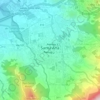
Name: Santa Ana topographic map, elevation, terrain.

Location: Santa Ana, San Jose Province, 10901, Costa Rica (9.92067 -84.19214 9.94349 -84.15944)

Average elevation: 3,120 ft

Minimum elevation: 2,736 ft

Maximum elevation: 4,337 ft

Gear up for your next adventure:

📚USA Hiking Guide Books - Top trail guides and map books
🪵Folding Camp Saw - Compact saw for wood and campsite work
Backpacking Tent - Lightweight and durable tent for multi‑day hikes
🪶Multi‑Purpose Knife - Useful blade for camp and trail
🌄Hiking Binoculars - Compact binoculars for scenic views and trail spotting

As an Amazon Associate, this site earns from qualifying purchases at no extra cost to you.