Geolocate

Taropo topographic map

Click on the map to display elevation.

About this map

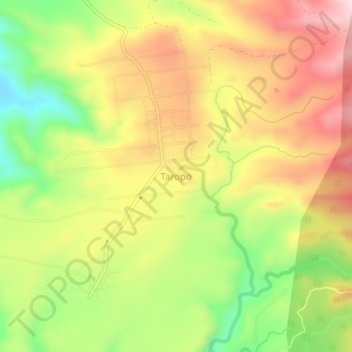
Name: Taropo topographic map, elevation, terrain.

Location: Taropo, Dompu, West Nusa Tenggara, Indonesia (-8.44162 118.32429 -8.40162 118.36429)

Average elevation: 617 ft

Minimum elevation: 46 ft

Maximum elevation: 1,142 ft

Gear up for your next adventure:

🧤Hiking Gloves - Protective gloves for rugged trails
🔥Camping Stove - Portable stove for camping and backcountry cooking
🛌Ultralight Sleeping Bags - Compact down bags for cold nights in the wilderness
👟Men's Trail Runners - Lightweight footwear for fast-paced exploration and light hiking
🪵Folding Camp Saw - Compact saw for wood and campsite work

As an Amazon Associate, this site earns from qualifying purchases at no extra cost to you.