Geolocate

Gary topographic map

Click on the map to display elevation.

About this map

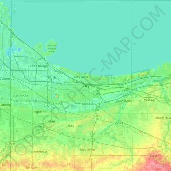
Name: Gary topographic map, elevation, terrain.

Location: Gary, Lake County, Indiana, 46402, United States (41.44213 -87.49714 41.76213 -87.17714)

Average elevation: 614 ft

Minimum elevation: 558 ft

Maximum elevation: 823 ft

Lake County trails, hiking, mountain biking, running and outdoor activities

Other topographic maps

Click on a map to view its topography, its elevation and its terrain.

Grand Calumet River

United States > Indiana > Lake County > Gary

Average elevation: 591 ft

Gear up for your next adventure:

🛰️Satellite Messengers - Emergency SOS and two-way messaging for off-grid adventures
🪶Survival Guide Book - Expert advice for emergency preparedness
📷Action Camera - Capture your outdoor adventures in HD
🔥Camping Stove - Portable stove for camping and backcountry cooking
🏔️Mountain Trail Maps - High‑detail maps for popular peaks

As an Amazon Associate, this site earns from qualifying purchases at no extra cost to you.