Geolocate

Sunsun topographic map

Click on the map to display elevation.

👉 Easily get elevation data in JSON, GeoTIFF and KML formats using Elevation API
Thank you for supporting this site ❤️
Make a donation

About this map

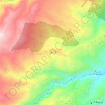
Name: Sunsun topographic map, elevation, terrain.

Location: Sunsun, Baños, Cuenca, Azuay, Ecuador (-2.97835 -79.10737 -2.93835 -79.06737)

Average elevation: 9,783 ft

Minimum elevation: 8,750 ft

Maximum elevation: 10,663 ft

Gear up for your next adventure:

🚗GPS Dash Cams - Record your scenic drives through mountain passes and canyons
🥄Camping Utensil Set - Lightweight utensils for outdoor meals
🛰️Handheld GPS Units - Professional satellite navigators for precise backcountry mapping
🔦Compact Flashlight - Reliable flashlight for emergencies
🖼️Topo Map Wall Art - Decorative topographic prints of famous peaks and regions

As an Amazon Associate, this site earns from qualifying purchases at no extra cost to you.