
Make a donation
Gear up for your next adventure:
As an Amazon Associate, this site earns from qualifying purchases at no extra cost to you.
Saint-Aimé topographic map
Click on the map to display elevation.
Make a donation
Gear up for your next adventure:
As an Amazon Associate, this site earns from qualifying purchases at no extra cost to you.
About this map
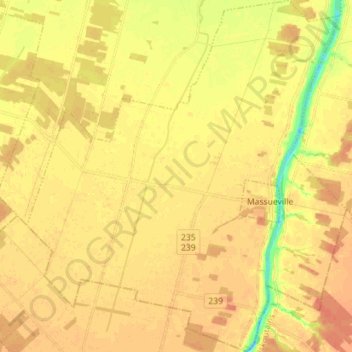
Name: Saint-Aimé topographic map, elevation, terrain.
Location: Saint-Aimé, Pierre-De Saurel, Montérégie, Québec, Canada (45.86910 -73.02663 45.96751 -72.89794)
Average elevation: 82 ft
Minimum elevation: -10 ft
Maximum elevation: 118 ft
Make a donation
Gear up for your next adventure:
As an Amazon Associate, this site earns from qualifying purchases at no extra cost to you.
Other topographic maps
Click on a map to view its topography, its elevation and its terrain.
Ruisseau Saint-Thomas et Sainte-Sophie
Canada > Québec > Pierre-De Saurel > Saint-Aimé
Average elevation: 85 ft
Make a donation
Gear up for your next adventure:
As an Amazon Associate, this site earns from qualifying purchases at no extra cost to you.