
Make a donation
Gear up for your next adventure:
As an Amazon Associate, this site earns from qualifying purchases at no extra cost to you.
Steffisburg topographic map
Click on the map to display elevation.
Make a donation
Gear up for your next adventure:
As an Amazon Associate, this site earns from qualifying purchases at no extra cost to you.
Steffisburg
Steffisburg liegt in einer voralpinen Hügellandschaft an der Zulg, am Rand des Berner Oberlandes. Steffisburg ist ein Vorort nördlich von Thun. Die Nachbargemeinden Steffisburgs sind Thun, Homberg, Fahrni, Unterlangenegg, Uetendorf und Heimberg. Das Zentrum liegt auf einer Höhe von 585 m. ü. M., der tiefstgelegene Punkt befindet sich im Aarefeld (550 m. ü. M.), der höchste Punkt im Bereich Schewendibach/Gibelegg (1034 m. ü. M) .
Make a donation
Gear up for your next adventure:
As an Amazon Associate, this site earns from qualifying purchases at no extra cost to you.
About this map
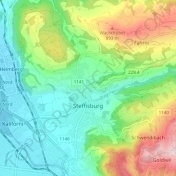
Name: Steffisburg topographic map, elevation, terrain.
Average elevation: 2,290 ft
Minimum elevation: 1,788 ft
Maximum elevation: 3,353 ft
Make a donation
Gear up for your next adventure:
As an Amazon Associate, this site earns from qualifying purchases at no extra cost to you.
Other topographic maps
Click on a map to view its topography, its elevation and its terrain.
Stockhorn
Schweiz > Bern > Verwaltungskreis Thun > Stocken-Höfen > Oberstocken
Auf der Simmentaler Seite, unweit des Gipfels, befinden sich zwei kleine Bergseen, der Oberstockensee und der Hinterstockensee. Der Hinterstockensee liegt hinter der Mittelstation „Crindi“, der Oberstockensee anderthalb Kilometer westlich auf gleicher Höhe, aber durch einen kleinen Bergrücken getrennt.…
Average elevation: 5,525 ft
Make a donation
Gear up for your next adventure:
As an Amazon Associate, this site earns from qualifying purchases at no extra cost to you.