
Thank you for supporting this site ❤️
Make a donation
Make a donation
Gear up for your next adventure:
As an Amazon Associate, this site earns from qualifying purchases at no extra cost to you.
Cahors topographic map
Click on the map to display elevation.
Thank you for supporting this site ❤️
Make a donation
Make a donation
Gear up for your next adventure:
As an Amazon Associate, this site earns from qualifying purchases at no extra cost to you.
Cahors
La superficie de la commune est de 6 472 hectares, l'altitude varie entre 105 et 332 mètres.
Thank you for supporting this site ❤️
Make a donation
Make a donation
Gear up for your next adventure:
As an Amazon Associate, this site earns from qualifying purchases at no extra cost to you.
About this map
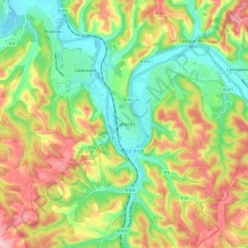
Name: Cahors topographic map, elevation, terrain.
Location: Cahors, Lot, Occitanie, France métropolitaine, 46000, France (44.40950 1.39650 44.48950 1.47650)
Average elevation: 656 ft
Minimum elevation: 348 ft
Maximum elevation: 1,066 ft
Thank you for supporting this site ❤️
Make a donation
Make a donation
Gear up for your next adventure:
As an Amazon Associate, this site earns from qualifying purchases at no extra cost to you.