
Make a donation
Gear up for your next adventure:
As an Amazon Associate, this site earns from qualifying purchases at no extra cost to you.
Waarbeke topographic map
Click on the map to display elevation.
Make a donation
Gear up for your next adventure:
As an Amazon Associate, this site earns from qualifying purchases at no extra cost to you.
Waarbeke
Waarbeke is een dorpje in de Belgische provincie Oost-Vlaanderen en een deelgemeente van de stad Geraardsbergen; het was een zelfstandige gemeente tot aan de gemeentelijke herindeling van 1977. Het dorp ligt in de Denderstreek aan de provinciegrens, waar de Vlaamse Ardennen overgaan in het Pajottenland, te midden van een sterk golvend landschap, waarvan de hoogte varieert van 35 m tot 80 m.
Make a donation
Gear up for your next adventure:
As an Amazon Associate, this site earns from qualifying purchases at no extra cost to you.
About this map
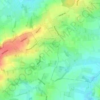
Name: Waarbeke topographic map, elevation, terrain.
Average elevation: 171 ft
Minimum elevation: 89 ft
Maximum elevation: 305 ft
Make a donation
Gear up for your next adventure:
As an Amazon Associate, this site earns from qualifying purchases at no extra cost to you.
Other topographic maps
Click on a map to view its topography, its elevation and its terrain.
Denderarm Sluis Geeraardsbergen
België > Oost-Vlaanderen > Aalst > Geraardsbergen
Average elevation: 125 ft
Make a donation
Gear up for your next adventure:
As an Amazon Associate, this site earns from qualifying purchases at no extra cost to you.
Provinciaal Domein "De Gavers"
België > Oost-Vlaanderen > Aalst > Geraardsbergen
Average elevation: 75 ft