
Make a donation
Gear up for your next adventure:
As an Amazon Associate, this site earns from qualifying purchases at no extra cost to you.
Villa de Ramos topographic map
Click on the map to display elevation.
Make a donation
Gear up for your next adventure:
As an Amazon Associate, this site earns from qualifying purchases at no extra cost to you.
Villa de Ramos
The municipality is located to the northwest in the state of San Luis, in the altiplano region. The municipal head or capital, has the following coordinates: 101*55' West longitude and 22*50' North latitude, with an elevation of 2,200 meters above sea level. Villa de Ramos is bordered by Santo Domingo to the North, Salinas de Hidalgoto the Southeast and the State of Zacatecas to the South and West. Distance from the municipality to state's capital is 81 mi (130 km).
Make a donation
Gear up for your next adventure:
As an Amazon Associate, this site earns from qualifying purchases at no extra cost to you.
About this map
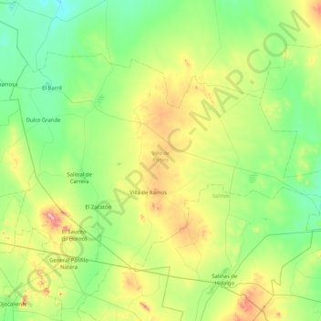
Name: Villa de Ramos topographic map, elevation, terrain.
Location: Villa de Ramos, San Luis Potosí, Mexico (22.65041 -102.26005 23.15832 -101.44627)
Average elevation: 6,864 ft
Minimum elevation: 6,309 ft
Maximum elevation: 8,527 ft
Make a donation
Gear up for your next adventure:
As an Amazon Associate, this site earns from qualifying purchases at no extra cost to you.
Other topographic maps
Click on a map to view its topography, its elevation and its terrain.
San Luis Potosí City
Mexico > San Luis Potosi > Municipio de San Luis Potosí
San Luis Potosí, commonly called SLP or simply San Luis, is the capital and the most populous city of the Mexican state of San Luis Potosí. It is the municipal seat of the surrounding municipality of San Luis Potosí. The city lies at an elevation of 1,864 metres (6,115 feet). It has an estimated population…
Average elevation: 6,575 ft
San Luis Potosí City
Mexico > San Luis Potosi > Municipio de San Luis Potosí
San Luis Potosí, commonly referred to as San Luis, or by its initials SLP (Otomi: Nmiñ'u), is the capital and the most populous city of the Mexican state of San Luis Potosí. It is the municipal seat of the surrounding municipality of San Luis Potosí. The city lies at an elevation of 1,864 metres (6,115…
Average elevation: 6,575 ft
Make a donation
Gear up for your next adventure:
As an Amazon Associate, this site earns from qualifying purchases at no extra cost to you.
Make a donation
Gear up for your next adventure:
As an Amazon Associate, this site earns from qualifying purchases at no extra cost to you.
San Luis Potosí City
San Luis Potosí, commonly referred to as San Luis, or by its initials SLP (Otomi: Nmiñ'u), is the capital and the most populous city of the Mexican state of San Luis Potosí. It is the municipal seat of the surrounding municipality of San Luis Potosí. The city lies at an elevation of 1,864 metres (6,115…
Average elevation: 6,575 ft
Matehuala
Mexico > San Luis Potosi > Matehuala
Matehuala is a city in the Mexican state of San Luis Potosí, situated at an elevation of about 1,500 m. Matehuala is also the municipal seat of the municipality of the same name, located in the northern part of the state, on the border with the southwestern corner of Nuevo León. The municipality of Matehuala…
Average elevation: 5,755 ft
Make a donation
Gear up for your next adventure:
As an Amazon Associate, this site earns from qualifying purchases at no extra cost to you.
San Luis Potosí City
Mexico > San Luis Potosi > Municipio de San Luis Potosí
San Luis Potosí, commonly referred to as San Luis, or by its initials SLP (Otomi: Nmiñ'u), is the capital and the most populous city of the Mexican state of San Luis Potosí. It is the municipal seat of the surrounding municipality of San Luis Potosí. The city lies at an elevation of 1,864 metres (6,115…
Average elevation: 6,575 ft
Make a donation
Gear up for your next adventure:
As an Amazon Associate, this site earns from qualifying purchases at no extra cost to you.
Make a donation
Gear up for your next adventure:
As an Amazon Associate, this site earns from qualifying purchases at no extra cost to you.
Guadalupe de los Faz
Mexico > San Luis Potosi > Matehuala > Guadalupe de los Faz
Average elevation: 5,443 ft
Cerrito de la Cruz
Mexico > San Luis Potosi > Municipio de San Luis Potosí > San Luis Potosí
Average elevation: 6,247 ft